Sandy's Written Creations
Writings by Sandra Harrison including poetry, essays, fiction, non-fiction; children's literatire.
White Plains After the Revolution, City Planning; Direction
Entry is update version of the section of “After the Revolution to Present Times” and “City Planning and Direction” in White Plains, New York: A City of Contrasts.
AFTER THE REVOLUTION TO PRESENT TIMES
After the Revolution ending in 1788, White Plains (WP) separated from Rye becoming a town. WP census of 1790 recorded a population of 505 of which forty-six were slaves. Agriculture was still the basis of the economy; most of the farms were small in size.
It would take the community years to recover from the war especially when many of the buildings along the Village Street (now where S and N Broadway are located) were destroyed by fire in 1776. Court house was rebuilt in 1787 over the foundation of the old one and in 1788 (till 1870) WP would alternate with Bedford as the county seat. Bedford incidentally had a larger population at that time and their 1787 court house is now a museum.
Presbyterian Church located on the street was not rebuilt till 1825. Unfortunately, the rebuilt church was by fire as well. It was also a wooden structure and was not replaced till 1855.
A Methodist Church (still at location on N Broadway and office for WP Rural Cemetery) was built in 1795 but after a fire on opening day, it was replaced in 1797.
In 1844, the Harlem Railroad Line, using steam engines, reached WP profoundly effecting the community. As the Business District (BD) moved closer to the railroad, the population grew and residential, commercial and government development also increased. The rails increased dairy production on farms (like the Gedney Farm) and industry. The rails were involved in bringing commuters from New York City and the conversion of farms into estates. The tracks near the station and the station buildings were changed a number of times.
To encourage the sale of tickets, the rail line offered package deals for commuters and coordinated with real estate developers and others to promote Westchester as a great place to escape the hot dirty City. Wealthy NYers found inexpensive land (that were former farms) in WP to build large estates, hospitals and safe havens for orphan children.
A new court house was built on Railroad Ave (now Main St) and opened in 1856 replacing the one on S Broadway. It was built from the rocks quarried at the Davis Quarry. Rocks and remnants of quarry can be found today at corner of Prospect Rd and Oakwood Ave.
WP became an incorporated village in 1866 and in 1899 the village boundaries expanded when it purchased land from North Castle to build its reservoir.
Electrical rails were introduced in 1910 and to protect pedestrians and other vehicles the tracks were put above ground in 1914. Pillars above the tracks on Main Street are marked for this date. As the use of the train grew, more former farms and even the estates the rich NYers had built were subdivided into single lots for home building. Some developers built homes laying out streets, putting in sewers and lines for water and power. Trolleys were introduced and connected the rail line to the neighboring areas and communities. They were eventually replaced and phased out by 1926 as the use of buses became more popular.

Pedestrian tunnels under the tracks date from this time as well as stairwells that go directly to tracks from street level. Pictured are what they looked like before renovations.


A new brick station was open in 1915. WP had a least 2 other stations before this one that were much smaller.

Remnants from the former building are still behind the Bank St Commons that was constructed on the site of the former station. Former building had been demolished many years prior to the apartments going in and there was a big hole filled with water.
Rail had different owners over the years, but Metro North took over the rail line in 1982 and built a new station to replace the 1915 one in 1987. In 2017 they agreed to update station in 2017 after NY State named the station a hub in NY’s Mass Rapid Transit plan. Redo of White Plains station was completed in 2021. Hudson Link buses are available connecting White Plains to Rockland County and areas around the bridge. Construction on the station began in 2018. City did a study to redevelop the areas near the station and are asking for developers to submit plans for review. City has had buses to CT as well.


From 1912 to 1937, the NY, Westchester and Boston Railway ran to WP from the Bronx on the east side of the city. The terminal for the line was located where Nordstrom Department Store is today. The retail development on Gedney Way is a result of the rail line going through this largely residential area.


Though, the rail no longer exists parts of its bed are now part of the Jack Harrington Greenway City of WP Walking Trail from Bolton Ave to the Scarsdale border. Other parts of the rail bed are visible but are not available for walking. The Greenway entrance to trail on Ridgeway has a display containing information about rail line. In the summer of 2020, work was completed on the extension of the Greenway north from Gedney Way to Bolton Rd. Tunnels for the rail line run under a number of city roads like the one under Bryant Ave can be viewed at the municipal lot on Mamaroneck Ave near the intersection with Bloomingdale Rd. The parking lot for Sam’s of Gedney Way (56 Gedney Way) cuts into the former trail bed.

White Plains Becomes a City:
WP tried to become a City as early as 1902; in 1908 tried to annex Greenacres Neighborhood of Scarsdale as well as parts of Greenburgh and West Harrison in its efforts. In 1910, Governor vetoed WP’s request to become a city that would have annexed parts of West Harrison; Greenburgh.
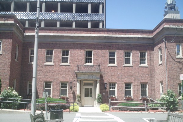
WP became an incorporated city on January 1, 1916 (after state approval in 1915) and would now include the Battle Hill section (of Greenburgh). City Hall on Main St opened in 1926. A marker stone near the handicap entrance is marked 1924. Today one can find war memorials in the lobby, pictures of past mayors and some of the drawings done by John Rösch (WP photographer and historian; dating from 1867).

The Police Department once occupied the annex that is behind City Hall but is now used as offices. A police station had been on Hamilton Ave till it moved to its present location at the WP Safety Building at 77 S. Lexington.
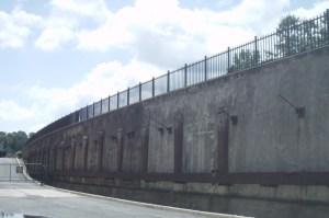
The Westchester section of the Bronx River Parkway was constructed between 1907 and 1925. The park along its route was created to protect the Bronx River from pollution and development. This was Westchester’s 1st park and the nation’s 1st public parkway. North of Yonkers, much of parkway’s bridges and other features are still in the original design. The Kensico Dam in Valhalla at the parkway’s northern end was constructed from 1913 to 1917. It replaced the first dam of 1885 that was taken down in 1911.

West of the tracks is a former bus depot that was repurposed into a restaurant Dog Den in 2016. The present bus terminal on Ferris Ave. connects commuters to areas in Westchester, Rockland and Connecticut is east of the Trans Center. City wanted to redevelop the transit hub to coordinate with the completion of Tappan Zee Bridge replacement. A yearlong study was conducted in 2016. The Trans Center started to be renovated in 2018 and was completed. There have been a number of new buildings that are in the process or planned for the areas around the station. Bridge was finished and opened as the Governor Mario Cuomo Bridge and a new bus line Hudson Link opened with connections in White Plains to areas across the bridge.

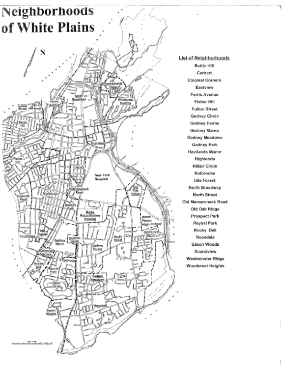
The trains that brought NY City closer to Westchester County and communities like White Plains had brought many wealthy New Yorkers who built country homes. They took advantage of the leisure activities that the area offered. Some of the city’s neighborhoods are named for these people (Hillair Circle, Idle Forest, Reynal Park, & Rocky Dell). Former farmland was also converted into hospitals, refuges for children, golf courses and even a large hotel Gedney Farm Hotel. See other sections on this website for more information listed at end of this posting. For more on transportation see “Transportation in WP” section.
CITY DIRECTION & PLANNING: As far back as the 1920’s, city planners had plans for WP to become a major commercial center in Westchester County by attracting some of NY City’s major department stores and Fortune 500 companies. Among these were B. Altman’s (1933), Macy’s (1949) and General Foods.
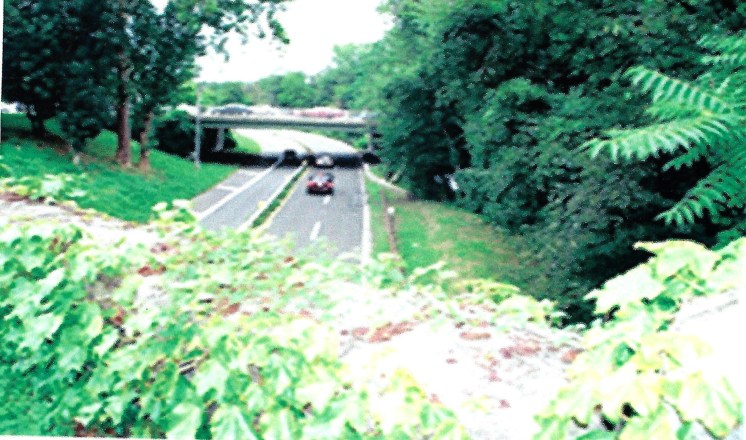
After years of construction, the Cross Westchester Expressway opened in 1960 and attracted even more companies. The roadway borders and cuts through parts of White Plains. A major renovation did occur starting in 1998 and sections of White Plains changed. A section of Lake Street (near S. & N. Kensico intersection) changed where 287 was redone. The changes took over a decade to complete and cost more than the first construction.
A huge urban renewal project from 1966 till 1980 removed entire blocks in the city to make way for new development including a new courthouse, library and two malls. The city lost residents during this time. Hundreds of Italian and Afro-Americans were displaced, and many small businesses were forced out. The WP Mall (1973) served the community during this period. Whole Blocks and streets were eliminated, and a number of much large office buildings and malls were constructed with some taking up entire blocks. The WP Mall (1973) housed some of the displaced businesses. The Mall was closed and demolished in 2022. Many businesses either closed or moved. One of tallest buildings constructed during this time was Westchester One (1975) on S Broadway.
In the 1980’s, many of the city’s older apartment buildings were converted to cooperatives and condominiums. The Galleria Mall opened in 1980. It closed March 2023 and will be redeveloped into a mixture of housing and retail space.
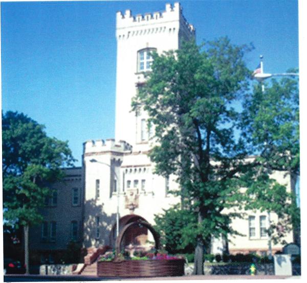
By 1977, the military use for the Armory dating from in 1910 and constructed on the site of the first 2 court houses, ended and was converted to a senior center and residence in 1982.
In 1995, The Westchester Mall opened. Numerous condominium townhouses and apartment buildings were constructed during the latter part of the 1900’s and the early part of the 21st century.
In 2000, the US census listed the population of WP as 53,077 and in 2010 as 56,853. Estimates of 250,000 have been given as to as to how many people come into the city daily. Tall towers of glass and concrete rose in the center of the city during the first part of the 2000’s. In recent years, with the sale of condominiums slowing, most apartment development in the city has been high end rentals.

A new building, The Prelude, opened on Quarropas Ave. in 2016 and is the first structure completed in Brookfield Commons (formerly known as Winbrook) by the WP Housing Authority (HUD). The older rental apartment structures from 1949 will be replaced and demolished. One building on S Lexington Ave was closed in 2016 and was demolished in 2020. The housing development is now using “Affordable” Housing to describe its offerings. The second building has been completed July 2022 called the Overture.
White Plains’ newest rental housing developments (since 2003) must include “affordable” options within their buildings. Despite these requirements for new housing, The City Center complex has an affordable option in a separate location in the complex “The Summit at City Center.” It is below the NY Sports Club and is actually hard to get to by way of two elevators. The City also has an affordable home ownership program for eligible families. There was a house available and units at Minerva Place Condominiums. For information see the City Website under Planning Department.
Considering how much WP changed during the 20th and 21st century, there are still remnants from earlier times. Some older buildings were saved by moving them to new locations and others by placing them on the National Registry of Historic Places. Many of the city schools and government departments as well as a number of hospitals, churches and other organizations were established in the later part of the 19th century and the early part of the 20th.
In the last number of years, the City has rezoned a number of areas in around the BD to revitalize them. Most of the projects involve a mixture of retail; rental apartments. Some are renovations but others involve demolition and rebuilds. The City Center & The Westchester underwent major renovations in 2016. For more information on newer structures and renovations see the section on White Plains Revitalization; Its Vanishing Past.
