Sandy's Written Creations
Writings by Sandra Harrison including poetry, essays, fiction, non-fiction; children's literatire.
White Plains, NY: A City of Contrasts

Entry is updated version of 1st 3 sections of White Plains, New York: A City of Contrasts published in 2013.
Remaining updated versions of the book can be found under different titles listed at the end of this entry.
Original Book (soft cover & e-book) is for sale with online venders. Facebook page for book under this title is also maintained by author and gives related info:


CONTRASTS: Today a modern suburb of New York City, White Plains (WP) is best known for its shopping centers, courts & services. Many come for work, study and entertainment. WP has an “urban” vibe offering services usually only available to much larger cities.
In contrast, WP played an important part in the American Revolution. Here NY became an independent state in the summer of 1776 and then in a few months’ time the setting for a standoff between the American Continental Army & the British Empire. Had things not gone as they did, America’s dream of independence might have been lost.
Throughout the city, one can still find remnants from earlier times. Many older structures have been repurposed for a purpose completely different from their original use.

BEGINNINGS: During the early 17th century, WP was home to members of the Weckquaeskeck tribe of the Mohican Nation. Evidence shows settlements on Fisher Hill. Natives referred to the area as Quarropas, which has been translated to mean “white marches” or “plains of white.”
Perhaps the best explanation for the city’s name is that there were once numerous wetlands on which a heavy white mist would often linger. Even though many of these wetlands are gone, mists still hover over the city where the tops of skyscrapers disappear. There is another explanation concerning groves of white balsam but John Rösch dismissed this since there were no traces of the plant by 1874.
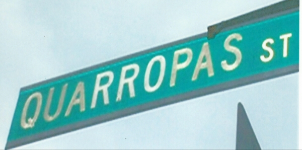
A number of old trails used by early inhabitants would become some of WP’s first roads. A number of streets still have Native American origins. Quarropas St is in the business district (BD). Nosband, Shapham and Orawaupum Avenues were named after sachems (tribal chiefs). Kensico , which is used for a number of streets, comes from the English spelling of Chief Cockenseco.
The Dutch, who came to North America following Henry Hudson’s explorations of 1609, set up trading posts, towns and forts along the Hudson River as far north as Albany. The colony of New Netherland was established with New Amsterdam as its center. Due to the high demand for furs in Europe, the colony flourished.
In 1644, the British took control of the Dutch colony renaming it NY after James II, the Duke of York and Albany. The Dutch retook the area briefly in 1673 but this ended in 1674 with the end of the Third Anglo-Dutch War. In 1683, NY was divided into twelve counties of which Westchester was one; the Bronx was part of it. People who came to the county found an abundance of forests filled with trees, wildlife, fertile lands and rocks that were readily available for trade, farming and building. Traders who came to the WP area referred to it as “White Plains.”
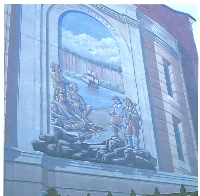
Settlers came to the colony during Dutch rule from all over Europe including Scandinavia, Germany, France and Belgium. French Huguenots and Jews came seeking freedom, while Africans were brought as slaves. Under British rule this tradition continued and was part of an agreement made with the Dutch avoiding a hostile takeover. Conflicts though with Native Americans often resulted in violence. Mural taken in Yonkers, NY around 2012 that depicted the meeting between Hudson and Natives of Manhattan (Lenape Tribe).
PURCHASE OF WP & COLONIAL TIMES:

On November 22, 1683, a group of Puritans from Rye bought 4,435 acres of land from the Weckquaeskeck and Siwanoy people. Sale took place alongside a lake in the area where The Westchester Mall is located. On the day of the purchase, WP was considered part of CT and then six days later after a boundary settlement, WP was part of NY.

Drawing “Purchase of the White Plains”) by John Rösch (former City historian) illustrates the purchase; is hung in WP City Clerk’s office at City Hall. WP Public Library has a photograph in their digital collection that one can access online that shows the rocks depicted in the drawing. Obviously, there are some historic depictions of Native Americans that are inaccurate in the drawing, but this is what was known at the time about native Americans during Rösch’s time. The Native Americans depicted are more like those in the mid-west (teepees and clothing) or the “plains.”
Soon after the purchase, John Richbell of Mamaroneck made a claim to the same land claiming that WP was part of a much larger purchase he made in 1661 with different Native tribes. John Richbell sent surveyors to the area, but they were driven off. After Richbell’s death in 1684, his claim was sold to Colonel Caleb Heathcoat of Scarsdale but he too failed to reclaim the land before his death in 1706. WP settlers petitioned the Governor of the NY Colony to grant them a royal patent that would give them the rights to the land, but it was not till 1721 that a royal decree was made. The city, though, did not forget John Richbell naming a street after him.
The settlers came from Rye by way of an Indian trail. This road appears on early maps as the “Road to Rye,” but in 1708 it was called “Queen’s Highway” named for Queen Anne. Today, it is known as North Street (St). During colonial times, WP remained a village in the Town of Rye.

By 1697, the Village of WP was centered along another Indian trail where N & S Broadway are today. By 1734, it was referred to as “The Village Street.” Open space called “the Commons” was designated for residential use by the community. The commons became the center of Broadway and then Broadway Park. In 1898, Charles Tibbits, a community member, founded WP Village Park Association to improve the park that would later be renamed in his honor.
Running through the park, is the Heritage trail with red & blue markers was created by the WP Monument Committee established in 1958; is now sponsored by the WP Historical Society. It is linked to Google maps at whiteplainshistory.org. An original map of the trail that includes different areas can be found on the Town of Harrison’s website (harrison-ny.gov).

Monuments in the park include the Civil War Statue, Christopher Columbus Statue, and the gun for WWI.


In 2009, the routes used by Generals George Washington & Jean-Baptiste Donation de Vimeur, Comte de Rochambeau (of France) during the later part of the Revolution were designated as a National Historic Trail. In 2016 makers were placed in Tibbits Park marking the route that comes through WP. Information about this trail can be found at the website nps.gov/warp/index.htm. Markers like these can be found elsewhere in the area along the route.
………………………..End Notes……………………………………
Other updated sections from book are: WP and the American Revolution and War Remembrances from the Battle of WP, Westchester County Seat and Government, Waterways in White Plains, WP’s 1st Village St, WP Older Houses, Historic Traces in WP BD, Houses of Worship, WP Schools History, Buried in WP, WP Quarry & Farms, WP Historic Businesses & Organizations, Memorials in WP & WP Hospitals. Sources for book are listed in a separate entry Sources for Further Study of WP.
Other entries about WP (not found in the book) can be found on this website are: Demographics in White Plains, What’s in a Name: The Bar Building, Battle of WP video, Art in WP, The Arts in White Plains: Past and Present, Seeking History One Foot at a time: WP’s Walking Tours, where is the Mamaroneck River in WP, What’s in a name? Bloomingdale Rd vs Bloomingdale’s, Presidents in WP, Martine Ave, Coloring for Adults: WP Photos, WP Neighborhoods, Origin of Names of Places in WP, Transportation in WP, How Well Do You Know WP?, Parking in WP, and Washington-Rochambeau Revolutionary Route National Historic Trail as well as many others.

Be aware that this version was revised and is now in the published version through Lulu.com.
LikeLike
That is a mistake but I first state that the house was from 1720’s in a previous paragraph. I left this out in my book when I reedited the script in the blog. I could not find an exact date for the construction. I, therefore, did not know if it was the oldest house in the city. If your father is still the owner, he might know more about the exact date of construction. You might check out my book, White Pains, New York: A City of Contrasts. The book is at the library and can be purchased either through Lulu or one of the other book services. Thanks for the feedback.
LikeLike
Dear Ms. Harrison,
I wanted to point out a (typographical?) error in your text regarding the Anthony Miller house at the end of Church St. I grew up in that house (my father is still the owner), and it was built in the 1720’s, not the 1920’s.
LikeLike
Ellen and Sandy, My family owned the Anthony Miller house at 379 Church Street from about 1954 to about July or August 1960. I went to Church St elementary school for grades 1-6. The White Plains newspaper published a picture of my mother, sisters and brother sitting on the front lawn which my mother still has. We also had pictures of the house being moved on a trailer with timbers under the house with a large truck, but I am not sure where those pictures are. My Dad was a very hard working man and he stripped all the paint off the house using propane torches and heated tools and then he repainted the whole house. As a boy I found handmade nails, large hooks and other old hardware which appeared to be made by Blacksmiths in the house. I visited the house in 1991 or 1992 and the gentlemen who owned the house at that time was I believe a college professor and he let me take a look around the inside of the house. When I lived there 1955-1960 I had a model train set of tracks mounted on a large plywood board with a painted paper mache diorama background which was mounted on hinges and folded down from the wall to lay flat on the floor. That set of Train tracks was still there when I visited in 1991.
When the Cross Westchester Freeway was opened and dedicated, then Governor Nelson Rockefeller came to the Grand Opening and I met him. I used to walk downtown to the YMCA and the RKO Keith Theater on Church Street.
Ellen who sold the house to your father and when did that sale occur? Any more information about the house or what happened after I moved away would be appreciated.
LikeLike
I did not find much about the Anthony Miller house in the White Plains Library (files) and because it is a private home I only viewed it from the streets. I can look up house at Assessors’ Office to see what they have. The house backyard is 287 so I have no other way to see the yard. I do remember seeing the newspaper article in the files and there were children outside the house. There is more about the Elijah Miller house on Virginia Road that is owner by Westchester County but it is now in poor condition. I have pics of both houses in my book that you can purchase online in e-version or paperback. Elijah was the son of Anthony Miller Sr.and his brother Anthony inherited family home. Record shows that Anthony Jr fought in White Plains Battle white his brother died before it serving the Continental Army. The homes used to be closer. I tried to find more about the Millers who had a mill on a stream that went from Bronx River. When looking for Miller family online I got conflicting info but one record had the Miller brothers were of about 8 children. Ellen contacted me through this blog so I do not know if this message will get to her. There is a women who can be contacted through White Plains Library who manages the Archives for city but I only met her when she was working for Westchester Archives. I doubt she can tell you much more. I am glad to find out more about this house that could have been demolished.
LikeLike
A Steve Taylor contacted me about the Anthony Miller house that he lived in till 1960. He wants to know more about when your family moved in and/or who they bought it from. I can look for info at Assessors office and then look up at County Clerk’s online service for info but you might want to add to Steve’s comment posted on this blog. I am surprised and pleased to find information about these old homes that are still left in the city. They keep tearing down old buildings in the city. The Hospital tore down an 80 yr building and a number of homes from early 1900’s have gone for apartment rentals. There are plans to tear down the former Alexander’s store that was repurposed for the Westchester Pavilion.
LikeLike
Trying to find out info on the Kempner Mansion that wa in White Plains at 800 North st. The mansion is now gone. Would love to see some pics of the entire property. My family owned the property up to the 1980’s. It was turned into a girls school at some time not sure of the date. Any help would be appreicated. I believe the Kempners were stock brokers and for that time were wealthy. ” P.S I love Gorillas” I have a silverback in my Office
LikeLike
I do not recall this house when doing research and did not find in “Yesterday in WP by Renoda Hoffman.” I also do not know about a girls school on North St. You can try e-mailing the WP Historical society with your questions about the house. My research worked from the present back and I was looking for old buildings predating 1940 that are still around. You might post a question on some of the Facebook pages about WP. Two (“You know you’re from WP”, and “WP Remembering…”) or the Historical Society’s Facebook page have people posting old pics of the city. I took over 4 years to do my research and I found it difficult, so finding a building that is no longer around, would be more difficult. Good Luck!
LikeLike
These are in fact great ideas in on the topic of blogging.
You have touched some good things here. Any way keep up wrinting.
LikeLiked by 1 person
You didn’t know that the Continuum 2 is completed and the westchester palvillon or the mall 8s been demolished and the white plains mall is about to be REPLACED w/ a mixed apartment.
LikeLike
My blog is actually an update of my 2013 book (stated at start). I was mostly concerned with older structures & organizations predating 1940. Continuum is a new structure that replaced a parking lot. Westchester Pavilion was a repurpose of former Alexander’s building but built after 1940. (see section on Business District (BD)). I know about the fate of many of White Plains (WP) structures but there are just too many to mention. That’s why I used the 1940 cut off. WP Mall was built in early 1970’s but don’t know when it will come down.
LikeLike